People need to prepare for the upcoming storm
Local news this week has focused on this possible upcoming snowstorm. Before going into details and predictions, it is crucial to understand that this storm is one of the most difficult storms to forecast thus far this season. There are so many factors that go into this storm that make it hard to forecast. The EURO model, which has been on point lately with its predictions, illustrates this storm doing somewhat of a loop-d-loop effect. It has the original storm (which is very powerful) coming up and into the coast. As it does this, the storm transfers its energy to another area of low pressure, about 100 miles or so east of the first storm. As both of these storms travel up the coast, they will drive heavy precipitation on the shore and progressively inland. For those who detest snow, things are looking up.
There is a chance that this storm stalls or moves very slowly up the coast and around snow bands on the back side as it exits out. Some weather apps and websites expect rain Tuesday during the day, and a mix of rain and snow Tuesday night. The following day, the forecast shows typically all rain Wednesday afternoon, and then a fusion of rain and snow all through Wednesday night. As for Thursday, there may be snow showers during the day that will eventually become a blending of rain and snow into the night. By Friday morning, the storm should cease with a mix of rain and snow.
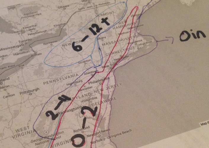
The biggest concern revolves around Wednesday night’s temperature with cold air and falling snow. This forecast is bound to change as the storm travels closer to the coast and new information emerges. Just like all of the other Nor’ Easters in the past, it is hard to get the snow totals, rain totals and timing correct. My snowfall map for the Northeast is subjected to change throughout the winter months, but it is my best forecast as of now. For now, bundle up and enjoy as much of the dry weather as possible.


